If you enjoy hiking in the Granby Land Trust’s preserves, you have probably noticed on the kiosks at the entrances to the properties that there is information on how you can download a map of the trails therein. The man behind this technology, who also happens to have made the kiosks, is Steve Perry.
While getting his bachelor of science in forestry at Michigan Technology University, Perry was introduced to geographic information systems (GIS), a form of computer mapping. (Perry notes that, “if you like the outdoors and long, cold winters, the Upper Peninsula is a wonderful place to go to school.”)
Although forests have remained an important part of Perry’s life, GIS became the focus of his career. His first employment was with The International Joint Commission in Windsor, Ontario, Canada where he studied water quality of the Great Lakes, followed by a stint with Maclean Consultants in Houghton, Michigan. In 1994, he took a job with the Southeast Michigan Council of Governments as their GIS coordinator/specialist, and simultaneously took classes at Eastern Michigan University where he obtained his masters in science in GIS/Remote Sensing in 1996. In 1997 and 1998, he was an adjunct professor teaching an introductory GIS course at the university. In 1999, he was the GIS technical manager for Wayne County, Michigan, and shortly after, married his wife, Shelley, who was a corporate pilot for the Ford Motor Company.
In 2003, Perry returned to work with the Southeast Michigan Council of Governments, where he remained until 2010. When Ford Motor closed its flight operations, Shelley began a job search that culminated in her landing a job flying for Mass Mutual Insurance, necessitating a relocation to someplace within a reasonable distance from Bradley International. Another requirement was that their chosen town have a good school system, for the couple now had two children: David, born in 2001 and Lindsey, born in 2004. After three trips to Connecticut, it was decided that Granby was the place they wanted to be. Shelley was impressed with then Wells Road principal, Dr. Anna Forienza-Bailey, and Steve was attracted to the rural forested environment, the sense of community and wonderful neighbors.
When the Perrys moved to Granby, the kids were 7 and 10 years old, and Shelley’s job took her out of town for extended periods of time. Finding it difficult to find a GIS job that didn’t require travel, Perry decided to be a stay-at-home dad to ensure a good transition for the kids and work on the many projects that were needed to be completed on the house. Knowing that GIS technology is constantly changing, he kept up to date on the data and the software, and as time went on, he was yearning to get back to work.
An opportunity presented itself when Perry was watching a Planning and Zoning meeting in which Fran Armentano demonstrated how the town was using GIS. Perry set up a meeting with Armentano, volunteering to help with the technology, and Armentano introduced him to the Granby Land Trust, which needed to have some mapping done for accreditation.
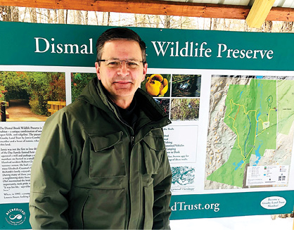
For the next three years, Perry helped map all the GLT properties, which entails gathering an assortment of data including parcels, aerial imagery, hydrology and elevation. He found a lot of the needed data online at sites hosted by the State of Connecticut and the University of Connecticut. Pulling all the data together, he was able to generate the desired maps, which supported and contributed to the Land Trust’s accreditation efforts.
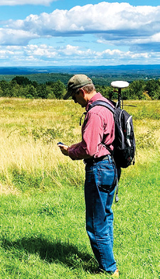
In 2017 Perry formed his own company, Sperry GeoSpatial LLC, and continued to provide mapping support to the GLT, along with high accuracy GPS field mapping. As more trails were developed, accurately mapped and used by many, it became apparent to Perry that there needed to be a way to offer visitors a map that could be downloaded on cell phones. He discovered the Avenza Map app, which allows hikers to see where they are on the trails in real time. Thanks to Perry’s work, each of the Land Trust’s properties with hiking trails has an associated map on the Avenza app.
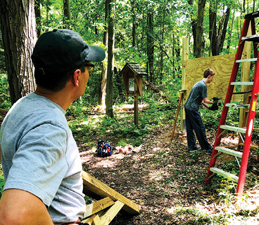
When the 150-acre Seth and Lucy Holcomb Preserve in North Granby was donated to the GLT, the Land Trust board sought to create a trailhead sign and kiosk that would allow recognition of the Holcombs and their vision for the property, provide a map of the trails and list property guidelines for visitors. Perry volunteered to take on the kiosk construction project and, after studying examples of various styles, presented one that the GLT agreed upon. Along with help from son David, Perry ended up building the sturdy kiosks for all the Land Trust trail heads, and also one for the Holcomb Farm Tree Trail.
Perry devised a number of templates, and all the material would be cut and the roof supports assembled at home before heading out to the properties. It was there that he discovered that the old adage that “you can’t dig a hole in New England with a spoon without hitting a rock” was definitely true. Digging the holes for the footings was the hardest part of the construction, but well worth it notes Perry: “It’s always a pleasure to see visitors gathered around the kiosks, learning about the property they are about to hike.”
Granby Land Trust president Rick Orluk notes that, “Steve is an invaluable asset to the Land Trust. He brings a tremendously valuable skill-set to our work and is one of the nicest folks you will ever meet. Our Board relies on him and our GLT members love working with him in the field.”
Perry doesn’t work all the time. He especially enjoys being out on the trails in the late fall when the colors are changing and there’s a crisp chill in the air. “I find myself stopping to sit on a rock by one of the many streams and listening to the sounds of the water and thinking how incredible it is to be able to enjoy this.” He also enjoys trying out new design ideas and new plants in his own yard, along with cutting and splitting firewood. Family time on the deck on a quiet evening listening to birds in the woods is a favorite relaxation.
In Perry’s own words: “I’m truly lucky to have been able to work with the GLT doing what I love, GIS mapping. The Land Trust members and volunteers have an incredible attitude on land preservation. Everyone I meet out on the trails always has the same response: ‘How wonderful to have these places to visit and explore.’ I couldn’t agree more.”